"Book your Extreme Wildlife Experience with Seven Safar, where you get Adventurous Jeep Safaris, Luxurious Resorts, Tour Packages and much more."
The Rupin Pass Trek is an exciting and challenging high-altitude trek that takes adventurers through the stunning landscapes of Himachal Pradesh. Spanning seven days, the trek begins in the village of Bawta, at an altitude of 2,350 meters (7,700 ft). From there, trekkers gradually ascend through picturesque villages like Jakha, Dandreyash Thatch, and Upper Waterfall, all the way to the Rupin Pass at 4,700 meters (15,350 ft).
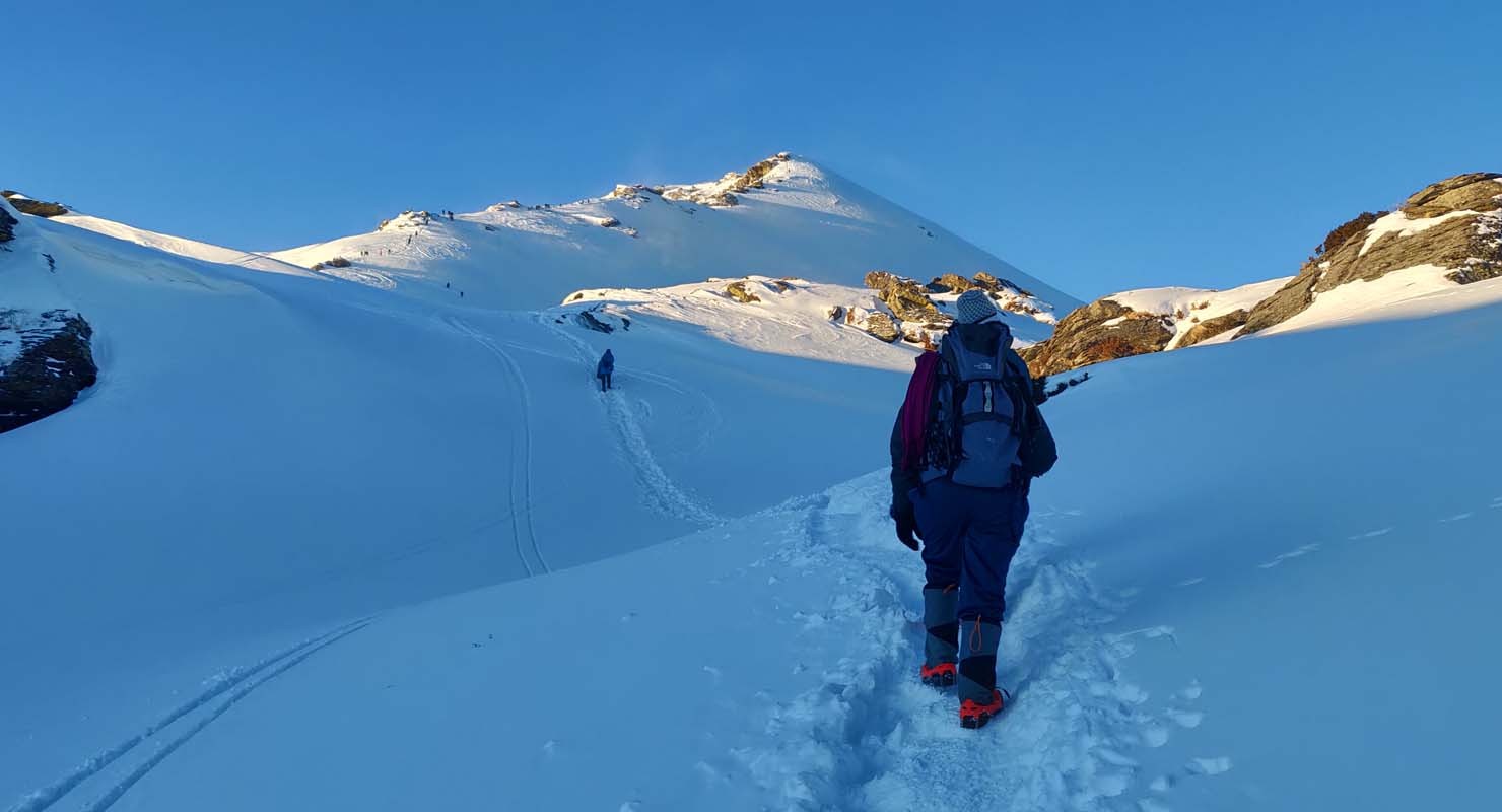
Along the way, trekkers traverse lush forests, steep climbs, alpine meadows, and awe-inspiring waterfalls, offering panoramic views of the surrounding mountains. The most challenging day is when trekkers cross the Rupin Pass itself, a thrilling experience marked by a 12-kilometer trek that takes 10-11 hours. The pass offers a unique view of the snow-covered peaks and alpine landscapes.
The trek also includes a buffer/acclimatization day to ensure trekkers adjust to the high altitudes. On the final day, the trek descends through Ronti Gad to Sangla, where a drive to Shimla concludes the journey. The Rupin Pass Trek is a perfect blend of adventure, natural beauty, and physical challenge, offering trekkers an unforgettable Himalayan experience.
| Resort Amenities | Inclusions | Exclusions |
|---|---|---|
| Homestay (dormitory with ground mattress.) | Insurance (Mandatory). | |
| Camping (Twin sharing basis) | Food during the transit. | |
| All meals from Day 1 Dinner to Day 7 breakfast as per the itinerary. | Any kind of personal expenses. | |
| 1 Versatile base camp manager handles communication and deploys extra manpower in emergencies | Mule or porter to carry personal luggage. | |
| 1 Mountaineering & First aid qualified professional trek Leader. | Emergency evacuation, hospitalization charge or etc. | |
| 1 Experienced high altitude chef. | Transportation (as per the itinerary): | |
| Local experienced guides (Number of guides depending on the group size). | Transportaion from Shimla to Bawta & Sangla to Shimla. | |
| Enough support staff. | Anything not specifically mentioned under the head Inclusion. | |
| Sleeping bag, Sleeping liners (if required), mattresses, and Utensils. | N/A | |
| 3 men all season trekker tent (twin sharing), Kitchen & Dining tent, Toilet tent. | N/A | |
| Camping stool, Walkie talkie. | N/A | |
| Ropes, Helmet, Ice axe, Harness, Gaiters & crampons (if required) | N/A | |
| Medical kit,Stretcher,Oxygen cylinder,Blood pressure monitor,Oximeter,Stethoscope | N/A |
Altitude Bawta: 2,350 m/ 7,700 ft.
Drive Distance: 195 km | 8 - 9 hr.
Pick Up Point: Old Shimla Bus Stand (Transportation is not included in the cost).
Stay: Home Stay
Last ATM Point at Rohru.
Our journey for Rupin Pass Trek starts from Bawta. You should reach Bawta one day prior to the trek. If you have booked your transportation from Shimla to Bawta with us, our team will pick you up from Shimla bus stand. You will driven from Shimla to Bawta from where we will start our trek next day. Bawta is a charming Himalayan hamlet located about 195 km from Shimla. Along the way, you will witness breathtaking views of nature and mountains. Keep your cameras on the ready because the scenery is going to be spectacular. On the way, you will pass the town of Rohru, a pleasant small town located on the banks of the Pabbar River. Rohru has the last ATM point post which there will be no cash withdrawal facility. From Rohru, you can see the road split in two - one leads to Janglik, the base camp for Buran Ghati Pass Trek and one leads to Bawta your base camp for Rupin Pass Trek.
Altitude Jakha: 2,750 m/ 9,000 ft.
Trek Distance: 5 km | 4 hrs.
Altitude Gain: 400 m/ 1,300 ft.
Difficult level of ascent, steep climb.
Moderate ascent till Jiskun then descent till wooden bridge through forest and then zig-zag ascent till Jakha.
Highest and the last village of Rupin pass trek.
Selwan Khad is the last water point.
Tea and Maggi shops are on the way.
BSNL network is available.
Hot lunch at campsite.
Stay in-home stay.
Today you will be crossing the highest and the last village of this trek. Plus the trail will be continuous ascent for 4-5 hours. So embrace all the energy before beginning on the jaunt on the zig-zag mixed trail.
After a moderate ascent till Jiskun, there will be a slight descending trail. You can find a wooden bridge between the dense forest. The route magically ascends in a zig-zag fashion from the bridge. Refill your bottles at Selwan Khad as this is the last water point of today. Do not worry, there are many tea shops on the way for more water. Rest in your peaceful home stay at night.
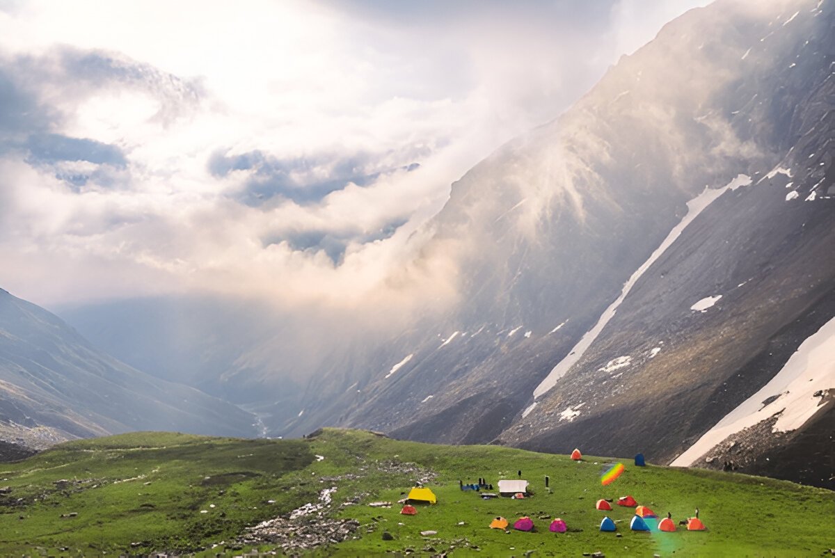
Altitude Dandreyash Thatch: 3,550m/ 11,700ft.
Trek Distance: 11 km | 8 hrs.
Altitude Gain: 800m/ 2,700ft.
Easy but long walk.
Most of the walk is along the river.
Can refill water bottles from the river.
Enjoy the snow bridges and wildflowers.
Trail surrounded by Silver birches (Bhoj trees) and rhododendrons (white, pink, purple).
A packed lunch will be given.
Stay in a tent.
Waking up at the campsite near Jhaka Village is sheer bliss. The trail is well-defined, passes through the field of Jhaka village, and enters a forest where trees of fir stand tall depicting centuries-old, pristine civilization. A turn in the trail past crossing the forest and landscapes changes itself to snow patches. Follow the snow bridge over Rupin, cross the bridge, and walk on a narrow trail to another wooden bridge.
Half an hour more walk on the boulders and hoping through the streams flowing within the rocky paths along the left of Rupin, you will enter another forest, on which rest the Rhododendron trees of a different color.
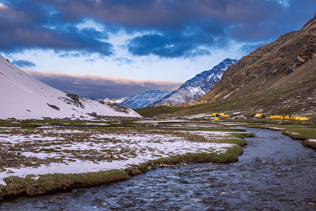
Another walk of a few kilometres and you are at Saruwas Thatch. Relax well and admire nature’s different shades on the perfect campsite, a serene u shaped valley in the middle of trees, with the sight of Rupin waterfall far away. Following this is the route filled with snow patches on the mountainside. The sacred silver birch trees (Bhoj Trees) will accompany you till the entrance of the forests. Move upwards through the forests and you will find yourself on the verge of U shaped valley. The enchanting sights from the lip of the valley, and thousands of waterfalls rushing down below you are all set to hypnotize you for a moment.
Move downward to reach down to the valley through green and yellow meadows, after crossing a series of snow bridges, and you are in the middle of a valley, Dhanderas Thatch.
get ready to relax and then indulge in some fun activities organized by us to enjoy one of the most admiring and biggest known meadows of the Himalayan Range.
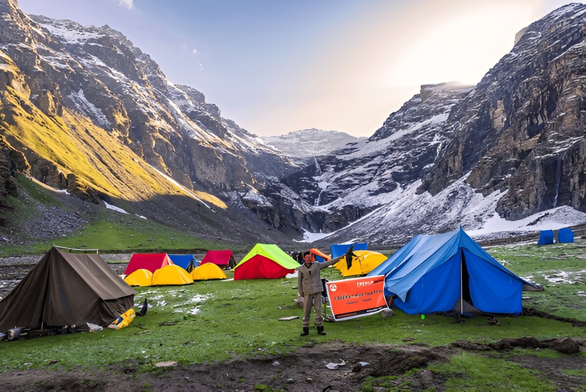
Altitude Upper Waterfall: 4050m/ 13,300 ft.
Trek Distance: 2.5 km | 3-4 hrs.
Can refill water from small streams.
Most scenic day of the trek.
Moderate level of ascent, continuously tricky climbing trail around the snow patches.
Avoid getting on the snow patch directly.
Meet the technical team they will give you important tips for the summit day.
Hot lunch at campsite.
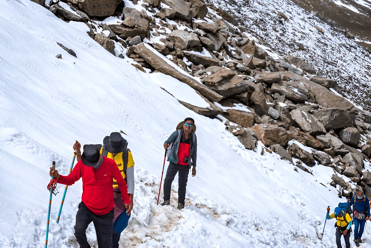
The altitude of Upper Waterfall Camp is about 13300 ft which is enough to make you vulnerable to AMS. We shall take the necessary precautions to keep away from any altitude problems. Our team will also take a short session to teach you the skills of trekking in the snow such as sliding on snow, side stepping, and cutting through the snow.
After proper acclimatization, you need to reach the base of Dhanderas, and from there, the trek crosses through many rivulets of Rupin. Make your way to the snow patch of the first waterfall through the marigold flowers. After a steady and careful walk on the rocks along the hill you can now see a trail going in between through the thick snow.
Your learned techniques will come is use as you have to cut your path to another vast snow bridge. This is the last but the ultimate snow bridge offering you the Rupin Water coming just above your head and getting down below your feet. A sharp but short climb after crossing the bridge and you are all set to get relaxed and enjoy your campsite.
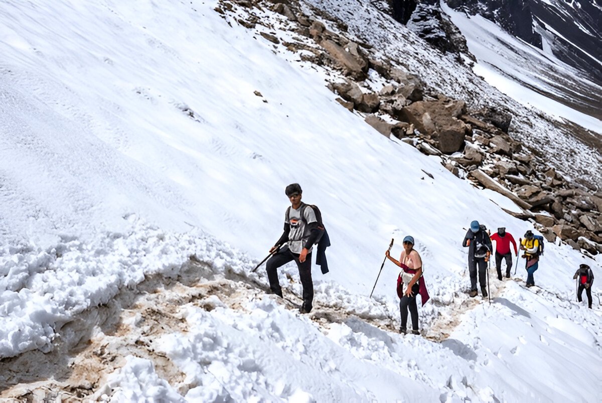
Altitude:
Rupin Pass: 4,700 m/ 15,350ft
Ronti Gad: 3,750 m/ 12,300 ft.
Trek Distance: 12 km | 10-11 hrs.
Altitude Gain: 650 m/ 2,050 ft.
Altitude Loss: 950 m/ 3,050 ft.
Difficult Level of ascent. Longest and most exciting day of the trek.
Steep ascent till the pass and then a steep descent.
200 mtrs of very steep ascent known as Rupin Gully, just before the pass, give a pass to porters and guides and let them go ahead.
Leave campsite by 4:30 am.
Carry enough hot water from the campsite, Water sources are limited.
A packed lunch will be given.
Reached Ronti gad late in the evening.
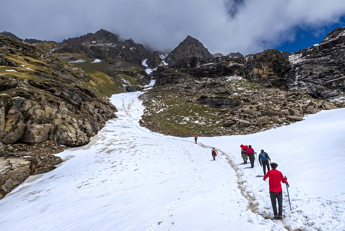
The longest trail of Rupin Pass begins with a steep ascent, with a bumper gain in altitude. After an hour of climbing, then take the left trail and discover totally different and amazing sights from the Rati Pheri campsite.
The only views from Rati Pheri are of the expanse of thick snow stretched all over, making your paths through them is your next exhausting task for the day to reach Rupin Pass Gully. We shall take utmost care here as the snow is very thick and the trails are not clearly defined. At Rupin Pass we will serve you with some refreshment to regain your energy for the next adventurous climb to Rupin Pass.
The trail to Rupin Pass is short but very uncertain and has risks of loose stones falling from above. Our team will suggest you walk in line carefully putting your every step forward.
Rupin Pass cut from a hollow-shaped region marks the beginning of Dhauladhar Range. A bit of descend and you are ready to experience the next adventure to slide down the snow to reach Rukti Gad.
Way to Ronti Gad is a gentle walk followed by a sharp descendant. Camping at the coldest yet charming campsite amidst the mountains covered with snow.
This day is a very important day of the trek, it greatly increases the chances of summit and this day cannot be ignored. This day can be used in any camp of the trek depending on the conditions at that time. Usually, it has been seen that many times trekkers get tired or the weather does not support them, due to which it becomes necessary to rest for 1 day, at that time this day helps us a lot and saves our planning from getting spoiled.
Altitude Sangla: 2,650 m/ 8,700 ft.
Trek Distance: 11 km | 5-6 hrs.
Drive Distance: 215 km | 9-10 hrs.
Moderate level of descent, continuously descent till Sangla.
Many water taps on the way.
Reach Sangla 1-2 pm.
Cab leaves from Sangla at 3 pm and reaches Shimla by 1 am (please make your hotel booking at Shimla accordingly).
Today’s trek will be a downward climb but very arduous as the trail’s altitude drops rapidly. Our team will take another round of about to make you adaptable to the sharp descendant, and climb your way downward with more ease without hurting your foot or knees.
Embark on a thrilling 4N/5D adventure to the stunning Kedarkantha Peak. Starting from Dehradun, you’...
View this Package
Chopta Tungnath trek serves as an unique adventure, providing you a blend of thrilling challenges, v...
View this Package
The Nag Tibba Weekend Trek offers an exciting and scenic escape into the Himalayas, perfect for adve...
View this Package