"Book your Extreme Wildlife Experience with Seven Safar, where you get Adventurous Jeep Safaris, Luxurious Resorts, Tour Packages and much more."
The Doodhpathri Trek is a thrilling 7-day journey through the remote and scenic landscapes of Kashmir. Starting from Srinagar, the trek takes you through lush meadows, high-altitude valleys, and beautiful alpine lakes such as Pamsar, Trastar, and Damamsar. With breathtaking views and challenging terrain, you’ll trek to altitudes up to 12,600 feet, exploring hidden gems like Ashtar Valley and Gurwansar Lake. This trek offers a perfect mix of adventure, nature, and tranquility for experienced trekkers seeking an unforgettable Himalayan experience.
| Resort Amenities | Inclusions | Exclusions |
|---|---|---|
| Camping while on trek (twin sharing) | Insurance (Mandatory) | |
| All meals while on trek (Veg) | Food during the transit. | |
| Day 1 Dinner to Day 7 Pack lunch | Any kind of personal expenses. | |
| Transport from Srinagar to DoodhPathri (Tata Sumo/equivalent non-ac) and return as per the itinerary. | Mule or porter to carry personal luggage. | |
| 1 Versatile base camp manager handles communication and deploys extra manpower in emergencies | Emergency evacuation, hospitalization charge, etc | |
| 1 Mountaineering & First aid qualified professional expedition Leader | Anything not specifically mentioned under the head Inclusion. | |
| 1 Experienced high-altitude chef. | Hotel Stay in Srinagar. | |
| Local experienced guides (Number of guides depending on the group size) | N/A | |
| Enough support staff. | N/A | |
| Sleeping bag, Sleeping liners (if required), mattresses, and Utensils. | N/A | |
| 3 men all season trekker tent (twin sharing), Kitchen & Dining tent, Toilet tent | N/A | |
| Camping stool, Walkie talkie. | N/A | |
| Ropes, Helmet, Ice axe, Harness(if required). | N/A | |
| Climbing Boots, Gaiters & Crampon /micro spike (if required). | N/A | |
| Medical kit, Stretcher, Oxygen cylinder, Blood pressure monitor, Oximeter, Stethoscope | N/A |
Drive distance: 55 km | 2.5 hours.
Pick-up point: Srinagar.
Stay in tents (twin sharing).
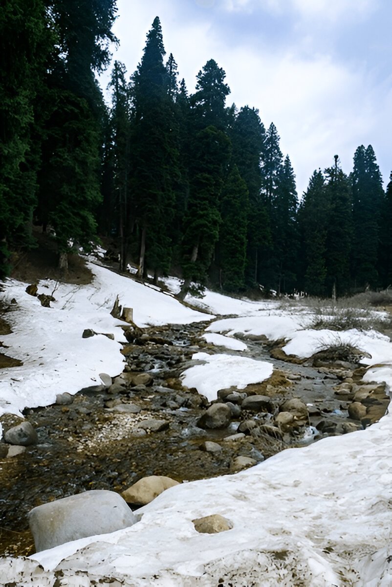
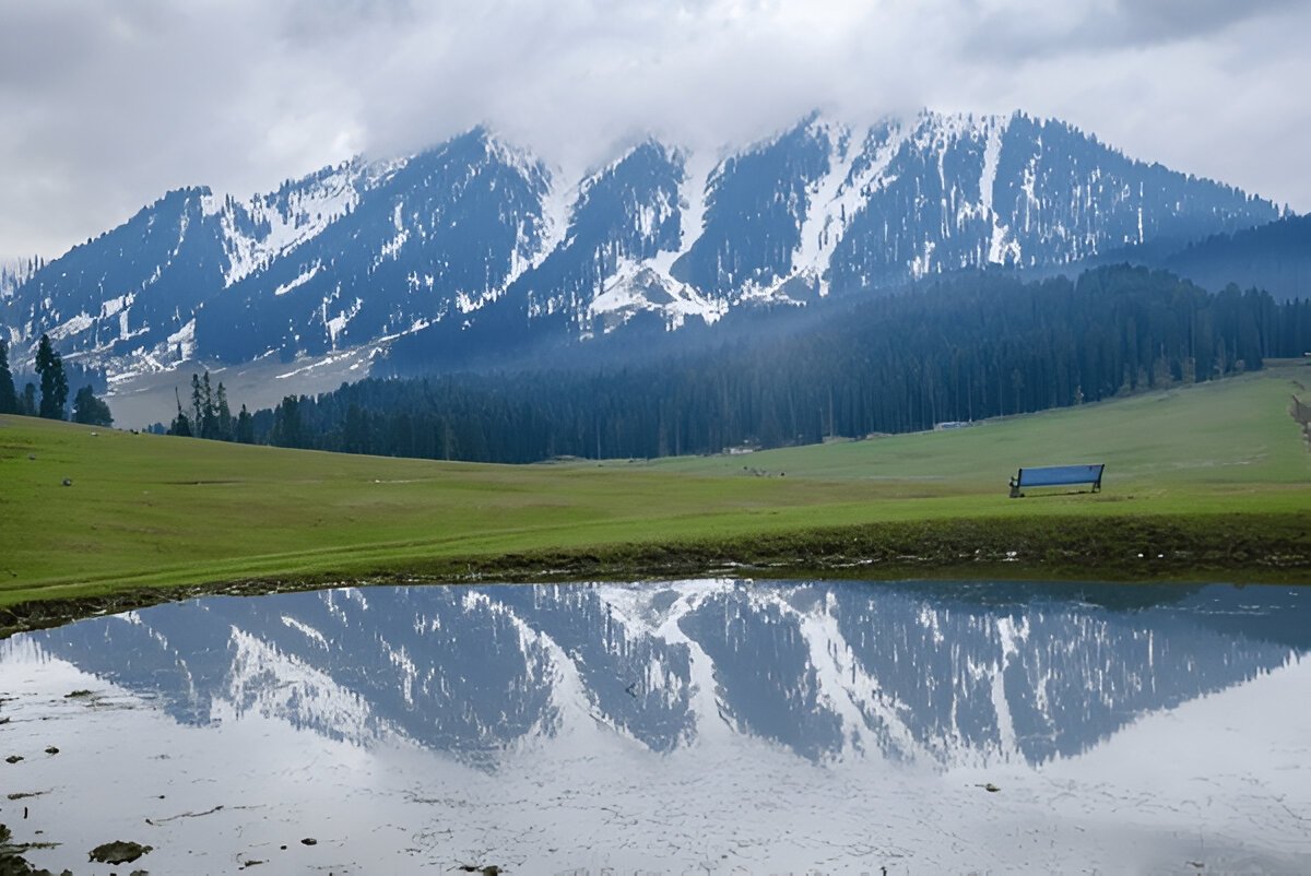
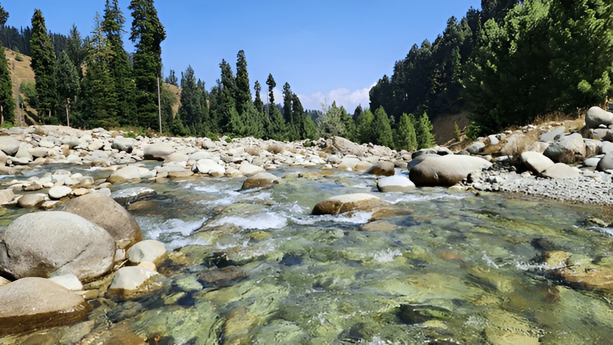
The trek begins from a place called Doodpathri, which is approximately 55 km from Srinagar. Our representatives will pick you up from Srinagar around 11 am and drive you to the Doodhpathri campsite. Doodpathri is a relatively undiscovered spot for tourists, however, it is a beautiful picnic and camping spot for the locals of Kashmir. The beautiful green meadows of Doodhpathri are quite similar to that of Gulmarg and the river flowing through the meadow gives you the hint of a similar scenery as that of Pahalgam. Tall pine trees loom around the meadows, making the meadows a perfect spot to camp for the night. You might even catch a few shepherds grazing their cattle around the meadows. You can roam around the meadows at your leisure in the evening and after a hearty dinner, retire to your camps for the night.
Trek Distance: 6.5 km | 5-6 hours.
Altitude gain: 8,900 ft to 10,600 ft.
Easy-Moderate. A gradual ascent through forests, and meadows.
This is the first trekking day. The gradient of the day is easy. You will start from the Doodhpathri meadow and after crossing the Dhoodhganga river you start ascending the forest cover. The ascend will take around 2 to 3 hours of mild-paced walking. The trail is definite and winds up until you reach above the tree line in the clearing called Diskhal meadow. This is from where the meadows start and will be your company until the end of the trek.
Here at Diskhal meadow, you will be welcomed by a small settlement of Shepherd.
Altitude: 11,500 ft.
Altitude gain: 10,600 ft to 11500 ft.
Trek distance: 4.5 km | 5 hours.
Stay in tents (twin sharing).
Ashtar Valley is a rangeland located near the foothills of Mt. Tatakoti. Tatakoti is the highest point of the Pir Panjal Range, which comprises numerous mountain peaks. You may observe the Shali Ganga River flowing through the valley, which flows to Doodhpathri and joins the Doodh Ganga River around Wathoora. The River flows from the Ashtar glacier, which you can see on your right-hand side once you reach the valley. During July, the entire valley is covered in yellow and red blooms. From Ashtar Valley, it’s a level walk of about 2 km before you reach the Ashtar campsite.
Altitude: 12,500 ft.
Trek distance: 7 km | 5-6 hours.
Altitude gain: 11,500 ft to 12,500 ft.
Moderate. Long gradual Ascents on meadows along with river crossing.
Today is also a fairly easy day of trekking as we trek to Gurwansar Lake. The trek is not difficult per se but what makes it a little tiring is that even though the ascent is gradual but the ascents are very long.
You cross some beautiful meadows and come across some river crossings on your way to Gurwansar Lake. The meadows are surrounded by a dense cover of pine trees, a beautiful sight to behold. This part of the trek is also great to spot a range of birds including the Golden Oriole. You will spot numerous sheep and lambs in the meadows herded by shepherds in the meadows. As you gain altitude, you will get inside cloud covers making for a surreal experience. The more you inch towards the lake, you will begin to see patches of snow depending on the time you are going on the trek.
The Gurwansar Lake sits in the middle of a meadow. In the month of May, the meadow is covered with floral bloom, especially Irish flowers. You can see a stream flowing from the Gurwansar Lake running through the middle of the valley creating a picturesque setting. During the winter months, the lake remains frozen. On the right of the Gurwansar, you can see a panoramic view of the Ashtar Valley that you had just crossed to reach up to the lake. We will camp by the lakeside tonight and in the vicinity of the campsite, you can spot numerous herbs like Saussurea costus, Taraxacum officinale, and Rheum Emodi. Enjoy your stay at this campsite marveling at its beauty of it.
Altitude:12,600 ft.
Trek Distance: 9 km | 7 hrs.
Altitude gain: 12,500 ft to 12,600 via 13,060 ft.
Moderate: Difficulty. Long walks, steep ascents through boulder sections.
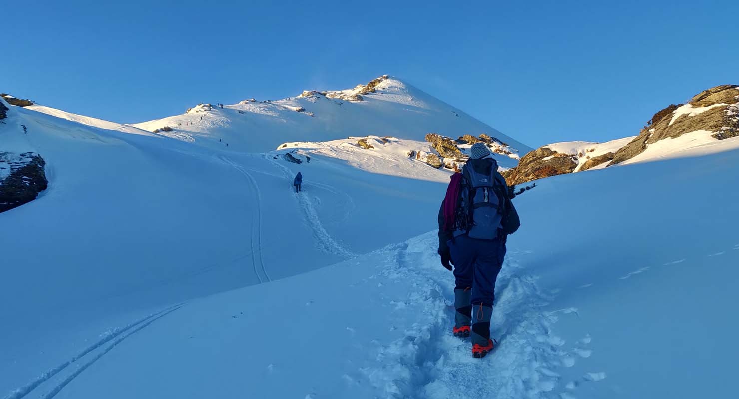
From Gurwansar campsite, it’s 9 km to Duriem. We will start the day as early as we can, as we have a long distance to cover and the trail is also moderately difficult. Follow the slope towards the west of Gurwansar Lake to head to Duriem via Pamsar Lake. About 20 minutes into walking, you will come across a bouldered section. The boulder section can be quite thrilling and gives an adventurous feel to the trek, although, you definitely need a good deal of fitness to cross this section. Be mindful while you cross the boulders as some of the rocks may be loose and shift disrupting your balance. After a gradual hike through the boulder, Pamsar Lake becomes visible.
It is a huge lake and you may not see it all at once. As you slowly inch closer to the lake, it begins to reveal itself. The beautiful lake is surrounded by a serenity that will soothe your senses. Sit down, and relish a few quiet moments here before you head onwards on your journey towards Duriem.
From the lake, you have to ascend a ridge to reach Duriem. You will ascend through a boulder section to reach a ledge. Continue walking until you reach the top of the ridge and once you reach the top, you can start your descent towards Duriem. Before you arrive at your campsite, you will have a stream crossing, which is quite a refreshing experience after a tiring day. We will pitch our tents after the stream crossing and retire for the night after dinner. Today has been a long day so rest well and recover for the next day’s trek.
Altitude:12,500 ft.
Trek Distance: 10-11 km | 8 hrs.
Altitude gain and loss: 12,621 ft to 12,545 via 13,000 ft.
Moderate - Difficulty. Long walks, steep ascents & descents through boulder sections en route to Bodhsar Lake & Navkansar Iake.
Today is going to be a long and interesting day as you spot not one or two but five beautiful lakes. Today also we will start the day early. From the campsite, you will start ascending towards to reach the first lake. After climbing for about 2.5 km, you will reach a point where you will go off the trail. From here you will start trekking towards Bodhsar Lake viewpoint. The viewpoint is about half a kilometer away towards the left. From this viewpoint, you can see the Duriem campsite. Also, keep an eye out for Tratsar Lake, also known as Lokutsar Lake.
After you have spent some time taking in the views and enjoying the beauty of the lakes, you will return back to the point where you started hiking toward Bodhsar Lake. Now you will ascend in the opposite direction through a bouldery section. The ascend becomes steep pretty soon. And continues for about a kilometer until you reach a flat portion of the ridge. This is a picturesque vantage point that unfolds a panoramic view of the lakes in front of you. Spending some time here, you will begin descending from the ridge and after about an hour of descending, you will begin to ascend again until you reach Damamsar Lake. The highest point of the ridge will give a beautiful bird’s eye view of Damamsar Lake as well as Navkansar I and II. This is a wonderful sight. One that stays with you for a long time. The lakes are formations from the snow that has melted from the surrounding mountains. Rejoicing in this captivating view for some time, we will descend all the way to the Gadtar campsite.
Altitude: 10,000 ft.
Trek Distance: 11 km | 5 to 6 hrs.
Altitude loss: 12,500 ft to 10,000 ft.
Drive Distance: 80 km | 3.5 hrs.
Difficulty: Moderate. Gentle descents along with river crossing on rocks.
Today is the last day of trekking, albeit also the longest. Start early as you have quite a long distance to cover. The trek starts with a wonderful river crossing post which you start ascending to a grassy ledge. There will be a couple of stream crossings today. You will mostly stay around the same altitude as you make ascends and descends until you reach the top of the ridge. Once you reach the top, you will again descend towards the second river crossing of your day followed by a mud trail. This trail also connects to the Tosa Maidan side.
Follow the trail and you will come across a water source and the third stream crossing for the day. This is the last leg of your trek after the river crossing. You can rest for a while if you want. The Tosa Maidan region starts at the end of the descent and it unfolds a very gorgeous vista in front of you, which is a pure treat to the eyes. Now, you will ascend for a short stretch of about 200 meters followed by a U-turn, and then again begin descending towards the diversion. Follow this trail and you will reach the road head soon. Once you reach the road head, mobile networks also start working.
From here, you will be driven to Srinagar, ending this beautiful sojourn in the mountains.
Embark on a thrilling 4N/5D adventure to the stunning Kedarkantha Peak. Starting from Dehradun, you’...
View this Package
Chopta Tungnath trek serves as an unique adventure, providing you a blend of thrilling challenges, v...
View this Package
The Nag Tibba Weekend Trek offers an exciting and scenic escape into the Himalayas, perfect for adve...
View this Package